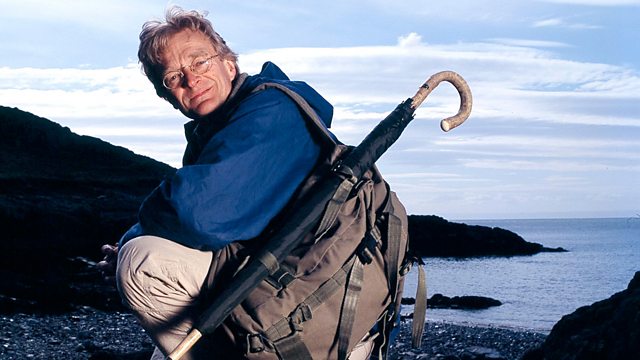
Martin Hotine's Ordnance Survey (1935-1950) Map Man
Similar Content
Browse content similar to Martin Hotine's Ordnance Survey (1935-1950). Check below for episodes and series from the same categories and more!
Transcript
| Line | From | To | |
|---|---|---|---|
This is John o'Groats, in northern Scotland. | 0:00:02 | 0:00:04 | |
It's the very end, or the very beginning, of mainland Britain. | 0:00:04 | 0:00:08 | |
Between here and the other end of Britain - Land's End, in Cornwall - | 0:00:08 | 0:00:12 | |
are 600 miles of mountains, forests, city, and farmland. | 0:00:12 | 0:00:15 | |
And the amazing thing is that every little bit of | 0:00:15 | 0:00:18 | |
those British landscapes is marked on one of these, an Ordnance Survey map. | 0:00:18 | 0:00:23 | |
Ordnance Survey maps | 0:00:27 | 0:00:28 | |
are incredibly accurate, incredibly detailed, | 0:00:28 | 0:00:31 | |
and incredibly successful. | 0:00:31 | 0:00:33 | |
This Landranger series sells two million copies a year. | 0:00:33 | 0:00:37 | |
Ordnance Survey maps are used by everyone, from hillwalkers | 0:00:37 | 0:00:41 | |
to fast-jet pilots. In fact, by anyone who needs to know | 0:00:41 | 0:00:45 | |
exactly where they are on British soil. | 0:00:45 | 0:00:48 | |
I'm going to take a journey across the toughest terrain in Britain, | 0:00:48 | 0:00:51 | |
the Highlands of northern Scotland, to find out exactly why these maps | 0:00:51 | 0:00:55 | |
are still regarded as the best in the world. | 0:00:55 | 0:00:58 | |
I'm starting my journey at Britain's busiest bomber base. | 0:01:24 | 0:01:29 | |
The Ordnance Survey began in 1791 as a military necessity. | 0:01:29 | 0:01:32 | |
You'd think that the modern RAF | 0:01:32 | 0:01:36 | |
would use ultramodern electronic maps for their navigation. | 0:01:36 | 0:01:40 | |
So they do, but just like us, | 0:01:40 | 0:01:42 | |
they use Ordnance Survey maps when they fly over Britain. | 0:01:42 | 0:01:46 | |
This room is where the pilots plan their missions. | 0:01:59 | 0:02:01 | |
To do so, they use a custom-made, | 0:02:01 | 0:02:04 | |
computerised navigation system and an OS map. | 0:02:04 | 0:02:08 | |
Stu Gillies is planning a navigation exercise, | 0:02:08 | 0:02:11 | |
using a series of prominent hilltops as his targets. | 0:02:11 | 0:02:14 | |
Stu will be flying at 500mph | 0:02:14 | 0:02:16 | |
over some key landmarks on my journey, | 0:02:16 | 0:02:19 | |
putting the Ordnance Survey maps to the test. | 0:02:19 | 0:02:22 | |
If you're going to fly an aircraft that low that fast, | 0:02:22 | 0:02:26 | |
you've got to be able to rely on very accurate maps. | 0:02:26 | 0:02:29 | |
You use an old-fashioned paper map? | 0:02:29 | 0:02:31 | |
The great thing about the 50,000 is that you get the big picture, | 0:02:31 | 0:02:35 | |
but you've got also very clear detail. | 0:02:35 | 0:02:39 | |
It's the same map as you've got there. | 0:02:39 | 0:02:42 | |
What we intend to do is come from Lossiemouth, south, then west, | 0:02:42 | 0:02:47 | |
-then head for Longa Island. -There's Longa Island. -Where you're going. | 0:02:47 | 0:02:52 | |
-Sithean Mor there. -Yeah. -Are you going to fly over them like that? | 0:02:52 | 0:02:56 | |
Because of the turning circle of the aircraft, I'll move that point out. | 0:02:56 | 0:03:00 | |
With aeroplanes, you have to keep them pointing at the right county, | 0:03:00 | 0:03:05 | |
or you end up in the wrong country! | 0:03:05 | 0:03:07 | |
And then up towards Caithness here. | 0:03:07 | 0:03:10 | |
Probably, to line it up, | 0:03:10 | 0:03:11 | |
-we'll come out to the north, then back down again. -So a triangle. | 0:03:11 | 0:03:16 | |
-Yeah. -Do you like looking at maps? | 0:03:16 | 0:03:19 | |
I have to admit, it's one of the pleasures of the job | 0:03:19 | 0:03:23 | |
because really, the map is, I think, a fusion of science and art. | 0:03:23 | 0:03:28 | |
You have the very accurate distances and heights and elevations marked. | 0:03:28 | 0:03:34 | |
For me, the great pleasure of flying is that | 0:03:34 | 0:03:36 | |
when you fly around this stuff, | 0:03:36 | 0:03:38 | |
that visualisation that you have often comes real. | 0:03:38 | 0:03:42 | |
Stu's list of targets will take him from Lossiemouth | 0:03:42 | 0:03:46 | |
to the Highlands of Wester Ross, | 0:03:46 | 0:03:48 | |
then up to Caithness and back. I'll make the same journey on the ground. | 0:03:48 | 0:03:53 | |
As in the song, he'll take the high road and I'll take the low road, | 0:03:53 | 0:03:57 | |
but we'll both use the same map! | 0:03:57 | 0:03:59 | |
The first stage in my journey takes me up to Gairloch, in Wester Ross, | 0:03:59 | 0:04:03 | |
in the Highlands of Scotland, | 0:04:03 | 0:04:05 | |
to discover how, more than 50 years ago, | 0:04:05 | 0:04:09 | |
small groups of men on foot managed to produce maps so accurate | 0:04:09 | 0:04:13 | |
that they can be used today by ground-hugging bombers. | 0:04:13 | 0:04:17 | |
The story of the modern Ordnance Survey map goes back to the 1930s, | 0:04:19 | 0:04:23 | |
when the decision was made to survey the whole country in one go. | 0:04:23 | 0:04:27 | |
The scale of the project was breathtaking. | 0:04:27 | 0:04:31 | |
It took nearly 30 years to complete. | 0:04:31 | 0:04:34 | |
The aim was to map the country to an accuracy of less than 20 metres. | 0:04:34 | 0:04:39 | |
The process really began far away in Wiltshire. | 0:04:39 | 0:04:43 | |
There, in 1937, on the Ridgeway Path near Swindon, | 0:04:43 | 0:04:47 | |
they measured by hand a distance on the ground just over 11km long. | 0:04:47 | 0:04:52 | |
This line, the Liddington baseline, | 0:04:52 | 0:04:54 | |
was to become the basis of the entire scheme. | 0:04:54 | 0:04:57 | |
It would form one side of a series of triangles, | 0:04:57 | 0:05:00 | |
which would eventually cover the whole of Britain. | 0:05:00 | 0:05:03 | |
Up here, in the Highlands of Scotland, the Ordnance Survey | 0:05:15 | 0:05:18 | |
faced their biggest challenge. | 0:05:18 | 0:05:20 | |
The place I'm headed for is so wild and so rugged that even today, | 0:05:20 | 0:05:25 | |
the Army uses it as a navigational training area | 0:05:25 | 0:05:27 | |
for their elite soldiers. | 0:05:27 | 0:05:31 | |
If things were going to go wrong, they'd have done so up here. | 0:05:31 | 0:05:34 | |
The master mapper of the enterprise | 0:05:42 | 0:05:44 | |
was Major Martin Hotine, of the Royal Engineers, | 0:05:44 | 0:05:48 | |
head of Triangulation and Levelling at the Ordnance Survey. | 0:05:48 | 0:05:52 | |
A veteran of World War I, | 0:05:52 | 0:05:54 | |
who had learned his trade in the hard schools of Afghanistan and Iraq, | 0:05:54 | 0:05:58 | |
Hotine was the brains behind the new survey. | 0:05:58 | 0:06:02 | |
Hotine was clearly an inspirational leader, | 0:06:02 | 0:06:06 | |
loyal to his troops and driven by a passion for accuracy. | 0:06:06 | 0:06:10 | |
He'd pick a fight with anybody who stood between him | 0:06:10 | 0:06:14 | |
and getting the correct result. | 0:06:14 | 0:06:16 | |
But first, he had to get the data, | 0:06:16 | 0:06:18 | |
and he did that in a characteristically Napoleonic fashion. | 0:06:18 | 0:06:23 | |
But how Napoleonic can map-making get? | 0:06:30 | 0:06:34 | |
I'm off to Longa Island to find out. | 0:06:34 | 0:06:37 | |
Hotine had decided that the survey required such a vast number of measurements | 0:06:37 | 0:06:42 | |
that the survey team's job should be made as simple as possible. | 0:06:42 | 0:06:46 | |
The surveyors would have to climb thousands of hilltops across Britain, | 0:06:48 | 0:06:52 | |
many of them extremely remote. | 0:06:52 | 0:06:54 | |
Each one would have to provide a footing for a theodolite, the surveyor's basic tool. | 0:06:54 | 0:07:00 | |
Hotine's solution was a grand concept in itself. | 0:07:00 | 0:07:04 | |
He invented a completely new feature for the British landscape, | 0:07:04 | 0:07:08 | |
one that's become familiar to millions, the triangulation pillar. | 0:07:08 | 0:07:13 | |
There's one of them on top of that island. | 0:07:13 | 0:07:16 | |
It is easy enough for the RAF to find its target on Longa Island, | 0:07:20 | 0:07:24 | |
but for me, it is a lot harder, | 0:07:24 | 0:07:26 | |
and for the pillar builders, it was even worse. | 0:07:26 | 0:07:29 | |
The pillars were made of concrete, which meant lugging bags of gravel, | 0:07:29 | 0:07:33 | |
sand and cement to what were often very inaccessible hilltops, | 0:07:33 | 0:07:37 | |
like one I am hoping to get to now. | 0:07:37 | 0:07:39 | |
Where they could, they transported all the raw materials | 0:07:49 | 0:07:52 | |
by lorry or, failing that, horse and cart. | 0:07:52 | 0:07:56 | |
but some spots were so remote that nothing short of human brawn would do. | 0:07:56 | 0:08:01 | |
I've lugged my 25 kilograms of cement ashore and this burden is just a small proportion | 0:08:02 | 0:08:08 | |
of the amount that the construction teams had to carry. | 0:08:08 | 0:08:13 | |
They would have been carrying more cement, sacks of sand, | 0:08:13 | 0:08:16 | |
sacks of gravel, picks, shovels, and their food and shelter. | 0:08:16 | 0:08:21 | |
And they were working in some of the most dramatic | 0:08:21 | 0:08:24 | |
and adventurous landscapes in the land., | 0:08:24 | 0:08:26 | |
but they were doing it for a very good reason. | 0:08:26 | 0:08:29 | |
It was a characteristically military approach - prepare the ground first | 0:08:29 | 0:08:33 | |
and then commence operations. | 0:08:33 | 0:08:35 | |
In true military style, | 0:08:35 | 0:08:37 | |
the manual laid down exactly what they had to carry. | 0:08:37 | 0:08:41 | |
A pillar complete with standard-sized base and block | 0:08:41 | 0:08:45 | |
requires 32 cubic feet of concrete. | 0:08:45 | 0:08:48 | |
At the required proportions, this represents cement - 4 cwt, sand - 11 cwt, and chippings - 16 cwt. | 0:08:48 | 0:08:55 | |
Hotine's reasons for building the pillars were entirely operational - | 0:08:55 | 0:08:59 | |
to ensure absolute accuracy. | 0:08:59 | 0:09:01 | |
These concrete tripods meant that each time a team returned to a particular place, | 0:09:01 | 0:09:08 | |
as they'd often have to do during the survey, they'd know | 0:09:08 | 0:09:11 | |
they were taking measurements | 0:09:11 | 0:09:13 | |
from the same place. | 0:09:13 | 0:09:15 | |
There'd be no chance of putting down a tripod in slightly the wrong place. | 0:09:15 | 0:09:19 | |
Hotine's measurements were set in stone, literally. | 0:09:19 | 0:09:23 | |
ROAR OF JET ENGINE | 0:09:23 | 0:09:25 | |
Once the pillars were up, | 0:09:30 | 0:09:32 | |
it was time for the surveyors to start laying down Hotine's triangles. | 0:09:32 | 0:09:38 | |
Here we are! | 0:09:38 | 0:09:40 | |
'Ian McManus, once a surveyor for the Ordnance Survey himself, | 0:09:40 | 0:09:44 | |
'has joined me at Sithean Mor near Gairloch to show me how it was done.' | 0:09:44 | 0:09:48 | |
-This is the daddy of them all. -That's the big theodolite? | 0:09:48 | 0:09:52 | |
'The theodolite was the key to the process because it measured not distances, but angles.' | 0:09:52 | 0:09:59 | |
OK, before we go up the hill, shall we just establish the principles of a triangulated survey? | 0:09:59 | 0:10:06 | |
We measure a baseline along one side of a triangle, between A and B. | 0:10:06 | 0:10:11 | |
We do that very accurately with a tape measure. | 0:10:11 | 0:10:15 | |
Then, again very accurately, we measure the angles of the triangle. | 0:10:15 | 0:10:19 | |
And then a very simple mathematical equation gives us the length | 0:10:19 | 0:10:24 | |
of the other two lines, doesn't it? | 0:10:24 | 0:10:26 | |
We measured that baseline and the three angles. | 0:10:26 | 0:10:29 | |
Mathematics does the rest. | 0:10:29 | 0:10:32 | |
At each corner of these triangles, you have a trig pillar, | 0:10:32 | 0:10:36 | |
then you just add triangles until the entire country has been surveyed. | 0:10:36 | 0:10:40 | |
-Simple. -That's the way to do it. | 0:10:40 | 0:10:43 | |
'Those who took part in Hotine's triangulation | 0:10:43 | 0:10:46 | |
'never forgot the experience.' | 0:10:46 | 0:10:49 | |
We were all single, we climbed these mountains | 0:10:49 | 0:10:52 | |
and got paid for it! It was fantastic. | 0:10:52 | 0:10:55 | |
Getting heavy, unwieldy equipment up one mountain is a very serious task. | 0:10:58 | 0:11:02 | |
Taking it up hundreds of mountains is an even more incredible thought. | 0:11:02 | 0:11:07 | |
Surveyors were issued with detailed instructions about the method to use. | 0:11:07 | 0:11:12 | |
The Triangulation Handbook left them in no doubt | 0:11:12 | 0:11:16 | |
how records were to be kept. | 0:11:16 | 0:11:18 | |
-That was the bible. -What was? | 0:11:18 | 0:11:20 | |
Each trig point had its own file with all the relevant information. | 0:11:20 | 0:11:25 | |
There's no way that I can undertake | 0:11:31 | 0:11:34 | |
a series of triangulation observations on my own, | 0:11:34 | 0:11:37 | |
so I've roped in the Dundonnell Mountain Rescue Team | 0:11:37 | 0:11:41 | |
who have put 15 men on 6 different peaks in a circle around this mountain behind me. | 0:11:41 | 0:11:47 | |
They're going to lead us up the mountain to the observation point by the trig pillar. | 0:11:47 | 0:11:53 | |
-Which way do we go? -The top's up there. -Oh, no! | 0:11:53 | 0:11:57 | |
In Gaelic, this mountain's called the hill of spirits. | 0:12:19 | 0:12:22 | |
I think I can see why. | 0:12:22 | 0:12:25 | |
But there's something else, too. | 0:12:25 | 0:12:27 | |
Because the heat haze distorts the accuracy of the readings in daytime, | 0:12:27 | 0:12:32 | |
all the surveying was done at night. | 0:12:32 | 0:12:35 | |
On all the peaks around us, our colleagues will shine a light towards our position at the trig pillar. | 0:12:35 | 0:12:41 | |
When they do so, we'll measure | 0:12:41 | 0:12:44 | |
the bearing with a theodolite. | 0:12:44 | 0:12:46 | |
This is a five-inch theodolite, self-centring. | 0:12:46 | 0:12:49 | |
It's a magnificent instrument. It sits in these slots? | 0:12:49 | 0:12:53 | |
It's a massive piece of precision engineering. | 0:12:53 | 0:12:57 | |
'The exact process of setting up the theodolite was laid down precisely | 0:12:57 | 0:13:01 | |
'in the triangulation handbook.' | 0:13:01 | 0:13:04 | |
-Did you know the handbook by heart? -Yes, oh, yes. | 0:13:04 | 0:13:07 | |
What do you remember from it particularly? | 0:13:07 | 0:13:11 | |
Thou shalt not fiddle the results! | 0:13:11 | 0:13:13 | |
The handbook also said that each bearing must be measured 32 times. | 0:13:15 | 0:13:20 | |
The results would then be collated back at base. | 0:13:20 | 0:13:24 | |
We need the Longa Island light on. | 0:13:25 | 0:13:27 | |
-Do you want the light on? -Yeah, light on! | 0:13:27 | 0:13:31 | |
Can we have the light on, please? | 0:13:31 | 0:13:34 | |
Just waiting for Longa Island light to come on. | 0:13:34 | 0:13:37 | |
I've got it! I've got it! | 0:13:37 | 0:13:40 | |
That's incredibly clear. | 0:13:40 | 0:13:42 | |
Just going to fine-set the light with the cross. | 0:13:44 | 0:13:46 | |
It's got to be right in the middle of the light. | 0:13:46 | 0:13:50 | |
Got it. OK, I'll read it off. | 0:13:50 | 0:13:52 | |
-Three, three, zero... -Three, three, zero... -Zero, six, two, nine. | 0:13:52 | 0:13:58 | |
-Zero, six, two, nine. Three, three, zero, zero, six, two, nine. -Correct. | 0:13:58 | 0:14:02 | |
OK, so the next one should be An Groban. | 0:14:02 | 0:14:06 | |
They haven't put the light on yet. We'll have to wait a sec. | 0:14:06 | 0:14:09 | |
OK, the light's on. | 0:14:09 | 0:14:11 | |
'They may look close in the darkness, | 0:14:11 | 0:14:14 | |
'but those lights are actually miles away, lighting up the Highlands from hilltops up to 3,000 feet high.' | 0:14:14 | 0:14:21 | |
-1812. -Correct. Next one. | 0:14:21 | 0:14:24 | |
Meall an Dubh. | 0:14:24 | 0:14:26 | |
'No-one has done anything like this for nearly 40 years.' | 0:14:26 | 0:14:30 | |
-God, this is difficult. -Imagine doing this 32 times! | 0:14:30 | 0:14:34 | |
There it is. It's on. | 0:14:34 | 0:14:36 | |
'Doing the initial observations was only the first step. | 0:14:38 | 0:14:42 | |
'The primary triangles were huge, with sides up to 30 miles long. | 0:14:42 | 0:14:47 | |
'The Ordnance Survey still had to put in the detail. | 0:14:48 | 0:14:52 | |
'That meant two further levels | 0:14:52 | 0:14:54 | |
'of triangulation, with the triangles getting smaller each time. | 0:14:54 | 0:14:58 | |
'When you're down to the size of a field, you get the tape measure out. | 0:14:58 | 0:15:03 | |
'This is the secret of the Ordnance Survey's reputation. | 0:15:03 | 0:15:07 | |
'Triangulation, as a means of avoiding errors on the ground | 0:15:07 | 0:15:11 | |
'and a foolproof method of pinpointing errors later, | 0:15:11 | 0:15:16 | |
'all because of the simple | 0:15:16 | 0:15:18 | |
'mathematical properties of triangles.' | 0:15:18 | 0:15:21 | |
Then and now, it was a hard struggle, but it was worth it. | 0:15:23 | 0:15:27 | |
There are many different series of Ordnance Survey maps, | 0:15:27 | 0:15:30 | |
but the two that I am using on this journey | 0:15:30 | 0:15:32 | |
are this one here - the 1:50,000 scale Landranger map - | 0:15:32 | 0:15:36 | |
which is as familiar to lovers of the Great Outdoors as | 0:15:36 | 0:15:39 | |
the British landscape itself, | 0:15:39 | 0:15:41 | |
and this one here - the 1:25,000 scale Explorer map - | 0:15:41 | 0:15:45 | |
which is particularly suitable for mountain navigation. | 0:15:45 | 0:15:49 | |
Now, the detail in the Explorer map is quite extraordinary. | 0:15:49 | 0:15:53 | |
It is absolutely crammed with geographical information, | 0:15:53 | 0:15:56 | |
so let's have a closer look. | 0:15:56 | 0:15:58 | |
If I flip it over to this area here, | 0:15:58 | 0:16:00 | |
we have got all sorts of diverse information, | 0:16:00 | 0:16:03 | |
all organised systematically, | 0:16:03 | 0:16:05 | |
because that's the key to a great map. | 0:16:05 | 0:16:07 | |
So we can start by looking at the contour lines, these brown lines | 0:16:07 | 0:16:11 | |
that indicate altitude above sea level, | 0:16:11 | 0:16:14 | |
and they are arranged at ten-metre intervals. | 0:16:14 | 0:16:17 | |
The closer together the contour lines, the steeper the gradient. | 0:16:17 | 0:16:20 | |
If they become vertical, you have a symbol for a crag or a cliff. | 0:16:20 | 0:16:25 | |
And then we have vegetation cover. | 0:16:25 | 0:16:27 | |
There are two different symbols for trees. | 0:16:27 | 0:16:30 | |
A coniferous forest is marked by little fir trees, | 0:16:30 | 0:16:33 | |
and then a deciduous forest is marked by something looking like | 0:16:33 | 0:16:36 | |
an oak tree. There is another symbol to show open grassland | 0:16:36 | 0:16:41 | |
and bracken, so you know when you are about to trip over tussocks of grass. | 0:16:41 | 0:16:45 | |
the built landscape is represented by all sorts of symbols. | 0:16:45 | 0:16:48 | |
So in a built-up area like Gairloch, | 0:16:48 | 0:16:50 | |
there is a police station marked, a school, several houses marked. | 0:16:50 | 0:16:55 | |
But the most amazing aspect of any Ordnance Survey map | 0:16:55 | 0:17:00 | |
is the unique system of grid referencing. | 0:17:00 | 0:17:02 | |
Ordnance Survey maps are covered by little squares. | 0:17:02 | 0:17:06 | |
On this map, they are quite large, | 0:17:06 | 0:17:08 | |
because it is a large-scale map. | 0:17:08 | 0:17:10 | |
Each of these squares is a one-kilometre square, | 0:17:10 | 0:17:12 | |
and it allows you to give any feature on the map | 0:17:12 | 0:17:15 | |
a unique six-figure number, a grid reference. | 0:17:15 | 0:17:19 | |
You read those off by starting along the bottom. | 0:17:19 | 0:17:22 | |
The first three are read off the bottom, | 0:17:22 | 0:17:24 | |
and the second three numbers are read off the side. | 0:17:24 | 0:17:27 | |
To demonstrate the kind of accuracy Hotine's survey was aiming for, | 0:17:32 | 0:17:36 | |
I've been set a little challenge. | 0:17:36 | 0:17:38 | |
The BBC's production team has dumped me by the roadside | 0:17:38 | 0:17:42 | |
and given me a grid reference to find. | 0:17:42 | 0:17:45 | |
The number they've given me is 844737. That's the grid reference. | 0:17:45 | 0:17:50 | |
Let's see where that is. 844, along the bottom. | 0:17:50 | 0:17:54 | |
737, I read that off down the side of the map. | 0:17:54 | 0:17:58 | |
Follow your finger along, 844737. | 0:17:58 | 0:18:01 | |
That grid reference is a tiny loch. | 0:18:01 | 0:18:03 | |
Actually, a lochan, it's so small, with an island in the middle of it, | 0:18:03 | 0:18:07 | |
or at one end of it. It's set behind some very rugged-looking mountains | 0:18:07 | 0:18:12 | |
on the far side of a wilderness of heather and bog. | 0:18:12 | 0:18:15 | |
So they've picked a knotty problem. | 0:18:15 | 0:18:17 | |
I'm going to use a technique called dead-reckoning navigation | 0:18:17 | 0:18:21 | |
and I'll start by going to a corner in the road. | 0:18:21 | 0:18:25 | |
There are two phases to a dead-reckoning exercise. | 0:18:28 | 0:18:30 | |
The first is to fix your precise location on the map. | 0:18:30 | 0:18:34 | |
I know exactly where I am, because there's a stream | 0:18:34 | 0:18:37 | |
running under the road and I'm on the apex of the bend. | 0:18:37 | 0:18:42 | |
Now I set my compass on a bearing, | 0:18:42 | 0:18:44 | |
which will be the first in a series of doglegs to my destination, | 0:18:44 | 0:18:48 | |
this remote lochan behind all the mountains. So I set my compass. | 0:18:48 | 0:18:53 | |
It tells me that I should go precisely up there. | 0:18:53 | 0:18:57 | |
In country like this, it's impossible to keep a straight path, | 0:19:01 | 0:19:05 | |
but if the map's correct, I need to be at the top of this stream. | 0:19:05 | 0:19:10 | |
What I need to do is keep going up. | 0:19:10 | 0:19:13 | |
Well, the rain's beginning to ease. Thank goodness. | 0:19:20 | 0:19:24 | |
This is one of the most useful bits of mountain kit I've come across. | 0:19:24 | 0:19:28 | |
Walking in the mountain ranges of Europe, you find that all the shepherds use umbrellas, | 0:19:28 | 0:19:34 | |
not just for the rain and the snow, | 0:19:34 | 0:19:36 | |
but it stops you getting sunburn in the intense sunlight. | 0:19:36 | 0:19:40 | |
You can also fend off rabid shepherd dogs and the odd wolf or bear. | 0:19:40 | 0:19:45 | |
I'm just going to check my compass bearing, | 0:19:45 | 0:19:48 | |
to make certain I'm not straying off course. | 0:19:48 | 0:19:51 | |
My next spot to aim for is that rocky hillock. | 0:19:51 | 0:19:55 | |
Well, here's the rocky knoll, but I can't see my destination. | 0:20:03 | 0:20:08 | |
It's vital that I don't get lost. | 0:20:08 | 0:20:11 | |
One way of making sure is to time myself to the way point I've chosen. | 0:20:11 | 0:20:16 | |
That's this crag, overlooking a stream. | 0:20:16 | 0:20:19 | |
According to the map, it's roughly 500 metres away. | 0:20:19 | 0:20:23 | |
In this country, that should take me about 15 minutes. | 0:20:23 | 0:20:27 | |
On days like this, I love my job! | 0:20:32 | 0:20:34 | |
Where HAVE they sent me? | 0:20:34 | 0:20:37 | |
Fantastic! | 0:20:52 | 0:20:53 | |
Here's the little cliff, and it's right above the elbow in the river, | 0:20:53 | 0:20:57 | |
and it's taken me exactly 15 minutes. | 0:20:57 | 0:21:00 | |
So far, so good. | 0:21:00 | 0:21:02 | |
Now I've got to reset the compass on the next landmark I'm going to use | 0:21:02 | 0:21:06 | |
on my dead-reckoning exercise to take me to this lake. | 0:21:06 | 0:21:10 | |
I'm going to choose a little rock outcrop marked on the map, | 0:21:10 | 0:21:14 | |
about 400 metres from here. | 0:21:14 | 0:21:17 | |
And... | 0:21:17 | 0:21:18 | |
it's on a bearing of eight degrees. | 0:21:18 | 0:21:21 | |
I'm jolly glad that Hotine's people have been here before me. | 0:21:25 | 0:21:29 | |
The weather up here can be extremely treacherous. | 0:21:29 | 0:21:32 | |
You have to be on the lookout all of the time. If the clouds roll in, | 0:21:32 | 0:21:36 | |
visibility can change very quickly. | 0:21:36 | 0:21:40 | |
Now I'm on this exposed ridge, the wind's incredibly strong and gusty, | 0:21:40 | 0:21:44 | |
which makes it even more dangerous than it was before. | 0:21:44 | 0:21:48 | |
These mountains are very difficult to find a route through. | 0:21:48 | 0:21:52 | |
I'll have to be careful because that mountain's covered in sheer crags. | 0:21:52 | 0:21:57 | |
It's going to throw me off course. | 0:21:57 | 0:22:00 | |
This is getting tense. | 0:22:09 | 0:22:11 | |
I'm now on my fourth dogleg bearing | 0:22:11 | 0:22:13 | |
and I'm completely dependent on the dead reckoning. | 0:22:13 | 0:22:17 | |
If I've made any mistakes, each one will have put me further out. | 0:22:17 | 0:22:21 | |
But if I haven't, and the map is as accurate as Hotine hoped, | 0:22:21 | 0:22:25 | |
the lochan should be just over this crag. | 0:22:25 | 0:22:28 | |
There it is! | 0:22:33 | 0:22:36 | |
Fantastic! | 0:22:36 | 0:22:37 | |
What a beautiful sight! There's the little loch, with its tiny island | 0:22:37 | 0:22:41 | |
sitting in the middle of nowhere. | 0:22:41 | 0:22:43 | |
That map has brought me the whole way from the road that I was dropped on | 0:22:43 | 0:22:48 | |
across several miles of the wildest and most rugged terrain in the UK | 0:22:48 | 0:22:52 | |
and has delivered me with pinpoint precision on a tiny puddle | 0:22:52 | 0:22:56 | |
in the middle of nowhere. | 0:22:56 | 0:22:58 | |
The accuracy of Hotine's triangulation is scarcely believable. | 0:22:58 | 0:23:03 | |
But there's more to it than that. | 0:23:03 | 0:23:06 | |
I've passed my test using a map based on Hotine's work. | 0:23:06 | 0:23:10 | |
But Hotine himself had to face a far stiffer test. | 0:23:10 | 0:23:14 | |
He had to produce a survey that was accurate across the whole country, | 0:23:14 | 0:23:18 | |
not just a few miles. | 0:23:18 | 0:23:20 | |
And on that scale, the danger was that errors would accumulate | 0:23:20 | 0:23:24 | |
and the results would be useless. | 0:23:24 | 0:23:26 | |
The Ordnance Survey weren't having that. | 0:23:29 | 0:23:32 | |
They wanted a single, consistent scheme of mapping across the whole country, | 0:23:32 | 0:23:38 | |
which raised the stakes further. | 0:23:38 | 0:23:40 | |
Would mathematical triangulation | 0:23:40 | 0:23:43 | |
be accurate across hundreds of miles of country? There's only one way to find out. | 0:23:43 | 0:23:47 | |
ROAR OF AIRCRAFT ENGINE | 0:23:47 | 0:23:51 | |
Back in 1937, they had measured the original baseline | 0:24:04 | 0:24:07 | |
as accurately as possible. | 0:24:07 | 0:24:09 | |
And now they faced their big test, here in Caithness. | 0:24:09 | 0:24:13 | |
After the first baseline, none of the triangles in Hotine's scheme | 0:24:13 | 0:24:17 | |
had actually been measured. | 0:24:17 | 0:24:19 | |
They'd all been calculated, | 0:24:19 | 0:24:21 | |
so to check the scheme's accuracy, they went back to measuring. | 0:24:21 | 0:24:25 | |
They chose a triangle up here, with sides 25 kilometres long, | 0:24:25 | 0:24:30 | |
a triangle as far away from Wiltshire as it was possible to get. | 0:24:30 | 0:24:34 | |
Then, in 1951, | 0:24:34 | 0:24:35 | |
they measured one of its sides with a 30-metre steel tape. | 0:24:35 | 0:24:40 | |
According to the maths, the distance between this trig pillar | 0:24:40 | 0:24:45 | |
and that one over there in the murk, | 0:24:45 | 0:24:47 | |
in the far corner of the survey triangle, | 0:24:47 | 0:24:51 | |
should have been 24,828.423 metres. | 0:24:51 | 0:24:56 | |
The question facing the Ordnance Survey was that | 0:24:56 | 0:24:59 | |
if they ran a tape measure between the two trig pillars, | 0:24:59 | 0:25:02 | |
whether that measured distance | 0:25:02 | 0:25:06 | |
would tally up with the computed distance. | 0:25:06 | 0:25:09 | |
If it did, it would be a miracle of modern science and of surveying. | 0:25:09 | 0:25:13 | |
But if it didn't, all Hotine's work would have been in vain. | 0:25:13 | 0:25:18 | |
'I've got with me some experts from the Ordnance Survey to show me what it was like.' | 0:25:19 | 0:25:25 | |
So you pull that, is that the idea? To get the tension right? | 0:25:25 | 0:25:30 | |
'Back then, the line they measured was laid out exactly, | 0:25:30 | 0:25:33 | |
'using a theodolite. That was just the start.' | 0:25:33 | 0:25:36 | |
I've no idea how you do this with frozen fingers. | 0:25:36 | 0:25:42 | |
'A 30-metre metal tape was made of a special alloy, | 0:25:42 | 0:25:44 | |
'which resisted the effect of temperature. | 0:25:44 | 0:25:47 | |
'To ensure its accuracy, the tape was tensioned to a force of 20 pounds.' | 0:25:47 | 0:25:51 | |
Point-nine-seven-one. | 0:25:53 | 0:25:56 | |
Each reading was taken four times. | 0:25:56 | 0:25:58 | |
That was done for nearly 25,000 metres | 0:25:58 | 0:26:01 | |
between the two trig points, | 0:26:01 | 0:26:03 | |
more than 800 separate measurements. | 0:26:03 | 0:26:05 | |
THEY SHOUT NUMBERS | 0:26:05 | 0:26:10 | |
29.818. | 0:26:13 | 0:26:18 | |
-What is the temperature? -Six degrees. | 0:26:18 | 0:26:23 | |
-Above freezing? -Yes. | 0:26:23 | 0:26:25 | |
Right, that's two done. Now we just have to get the average distance between the two measurements, yes? | 0:26:27 | 0:26:32 | |
-Are we allowed to do that down in the pub? -Yep. | 0:26:32 | 0:26:37 | |
'It took them 54 days | 0:26:38 | 0:26:41 | |
'and only nine were lost to wind and rain. | 0:26:41 | 0:26:43 | |
'Today, that distance takes a Tornado just over two minutes.' | 0:26:43 | 0:26:47 | |
This is the other end of the baseline. | 0:26:58 | 0:27:01 | |
I'm nearly 25 kilometres from the John O'Groats pillar. | 0:27:01 | 0:27:06 | |
When the surveyors reached this point, | 0:27:06 | 0:27:09 | |
they sent their measurements back to Southampton | 0:27:09 | 0:27:12 | |
and waited for the results. | 0:27:12 | 0:27:15 | |
They were absolutely astonishing. | 0:27:15 | 0:27:17 | |
After measuring the entire Caithness baseline, a distance of around 25,000 metres, | 0:27:17 | 0:27:23 | |
they found that the difference between the amount that they expected from triangulation | 0:27:23 | 0:27:29 | |
and the distance that they got through measuring it with a tape measure was only 42 centimetres, | 0:27:29 | 0:27:36 | |
a scarcely believable level of accuracy. | 0:27:36 | 0:27:39 | |
And that was after measuring through triangulation | 0:27:39 | 0:27:43 | |
the 550 miles from the Liddington baseline to the Caithness baseline. | 0:27:43 | 0:27:47 | |
So Hotine's painstaking approach to surveying had been vindicated. | 0:27:47 | 0:27:52 | |
42 centimetres! | 0:27:56 | 0:27:59 | |
Less than 17 inches... after 550 miles. | 0:27:59 | 0:28:03 | |
Astonishing! | 0:28:03 | 0:28:05 | |
It's that amazing accuracy and meticulous detail | 0:28:07 | 0:28:11 | |
which enables the RAF pilots to hit their targets with pinpoint accuracy | 0:28:11 | 0:28:15 | |
and frees the British people to roam right across their own country. | 0:28:15 | 0:28:20 | |
And all because of the monumental efforts | 0:28:20 | 0:28:23 | |
made more than half a century ago. | 0:28:23 | 0:28:26 | |
Hotine and his Ordnance surveyors | 0:28:26 | 0:28:29 | |
set the British map record straight for good. | 0:28:29 | 0:28:33 |